Knowledge Base
| Category: Carlson GIS | ||
| Topic ID: 1096 | ||
| Title: How To Export GIS Data From Carlson GIS Desktop For Use with SurvCE | ||
| ||
Pulldown Menu Location: GIS Data Keyboard Command: msd2survce Prerequisite: CRD file, FLD file, points in drawing with MSC This command is used to set up a SurvCE Feature Code Library (.FCL) with attributes from points in a drawing with Esri MSC data. 1. From the GIS Data menu, choose Export GIS Data to SurvCE. This command takes selected data from the drawing and creates the GIS files that SurvCE uses. | ||
| ||
| ||
|
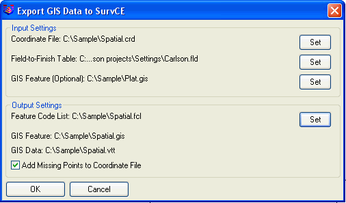 Input Settings:
The Files which are set in your Input Settings, will define the data to be Exported for use with SurvCE.
Coordinate File: Contains the point database with point#, x, y, z and description.
Field-to-Finish Table: Defines the coding for the description field that will be converted into a Feature Code List for SurvCE.
GIS Feature: Defines the feature and attribute names. Using this file is optional and applies in case that the feature definitions contain more features or attributes than the data entities.
Output Settings:
Specifies the names of the files to be uploaded to SurvCE.
Feature Code File: This is the SurvCE format file for the description field coding definitions. Once you have named your .FCL, all related files (.gis and .vtt) will use the same name.
GIS Feature: This defines the feature and attribute names. This file is automatically named after the Feature Code File.
GIS Data: This file contains the attribute data. This file is automatically named after the Coordinate File.
Add Missing Points to Coordinate File: This option creates points in the Coordinate File for any selected point entities that aren't already in the Coordinate File.
2. After specifying the files, click OK. The program prompts for the entities from the drawing to export. You can select the entire drawing by entering "all", or select a subset of the drawing entities. The program will read the GIS data from the selected entities to create the GIS data file (.vtt) for SurvCE.
3. Now that the project data is converted to SurvCE format, upload the coordinate file, feature code list, GIS feature, GIS data and drawing onto the SurvCE data collector. If you have SurvCE 2.5 or later, then you can use the DWG file format for the drawing. For earlier versions, use the DXF format. Depending on your collector and connections, you can do the upload with either Carlson Survey->Data Collectors->SurvCE, or Windows ActiveSync, or transfer on a data card. For this example, we have spatial.crd, spatial.fcl, spatial.gis, spatial.vtt and spatial.dwg to upload.
Input Settings:
The Files which are set in your Input Settings, will define the data to be Exported for use with SurvCE.
Coordinate File: Contains the point database with point#, x, y, z and description.
Field-to-Finish Table: Defines the coding for the description field that will be converted into a Feature Code List for SurvCE.
GIS Feature: Defines the feature and attribute names. Using this file is optional and applies in case that the feature definitions contain more features or attributes than the data entities.
Output Settings:
Specifies the names of the files to be uploaded to SurvCE.
Feature Code File: This is the SurvCE format file for the description field coding definitions. Once you have named your .FCL, all related files (.gis and .vtt) will use the same name.
GIS Feature: This defines the feature and attribute names. This file is automatically named after the Feature Code File.
GIS Data: This file contains the attribute data. This file is automatically named after the Coordinate File.
Add Missing Points to Coordinate File: This option creates points in the Coordinate File for any selected point entities that aren't already in the Coordinate File.
2. After specifying the files, click OK. The program prompts for the entities from the drawing to export. You can select the entire drawing by entering "all", or select a subset of the drawing entities. The program will read the GIS data from the selected entities to create the GIS data file (.vtt) for SurvCE.
3. Now that the project data is converted to SurvCE format, upload the coordinate file, feature code list, GIS feature, GIS data and drawing onto the SurvCE data collector. If you have SurvCE 2.5 or later, then you can use the DWG file format for the drawing. For earlier versions, use the DXF format. Depending on your collector and connections, you can do the upload with either Carlson Survey->Data Collectors->SurvCE, or Windows ActiveSync, or transfer on a data card. For this example, we have spatial.crd, spatial.fcl, spatial.gis, spatial.vtt and spatial.dwg to upload.